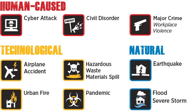
From nature’s wrath to human error, hazards exist throughout the world and Palo Alto is no exception. While we can't prevent all hazards from occurring, we can be aware and prepare for them to minimize their impacts on our lives.
No matter what happens, we want everyone to be prepared: stay informed / make a plan / build a kit and get involved. Visit these pages to make sure you know how to prepare.
We also recommend visiting Palo Alto's Neighborhoods' Palo Alto Ready, a website with emergency preparedness information for young and old (see their Families section), rich and poor (see Small Spaces, Tight Budgets or Too Busy in their Are You Ready? section), and everyone in between. They also have links to emergency preparedness information for Businesses, Faith-Based and Community-Based Organizations, Schools, and Libraries in their Community Partners page.
1. Natural hazards are naturally occurring physical phenomena caused either by rapid or slow onset incidents which can be geophysical (earthquakes, landslides, tsunamis and volcanic activity), hydrological (avalanches and floods), climatological (extreme temperatures, drought and wildfires), meteorological (cyclones and storms/wave surges) or biological (disease epidemics and insect/animal plagues).
2. Technological hazards (complex emergencies/conflicts, infrastructure failures, industrial accidents and transportation accidents) are the negative consequences of human innovation that can result in the harm or destruction of life, property, or the environment.
3. Human-Caused, also called Intentional, hazards exist not due to accident or nature, but as a result of the conscious decision of man to act in an antisocial or anti-establishment manner.
We have identified the following as the primary threats and hazards of most concern to our city and our citizens.
2017 Palo Alto Threat and Hazards Identification and Risk Assessment(PDF, 914KB)
Threats and Hazards Brochure(PDF, 9MB)
CAL OES MyHazards Tool
About
The Palo Alto Local Hazard Mitigation and Adaptation Plan identifies and prioritizes potential and existing hazards across jurisdictional borders, including hazards that may be further amplified by climate change. In an effort to guide the ongoing hazard mitigation efforts, mitigation objectives are identified with prioritized actions for each objective. Through mitigation projects, hazards will have smaller impacts on Palo Alto in the future.
Why does Palo Alto need one?
The Federal Disaster Mitigation Act of 2000 (DMA) requires all cities, counties, and special districts to adopt a Local Hazard Mitigation Plan to receive disaster mitigation funding from the Federal Emergency Management Agency (FEMA). This plan must be adopted by local government every five years.
Download the 2017 Palo Alto Local Hazard Mitigation and Adaptation Plan (PDF)
Download the Santa Clara County LHMP Volume 1 (PDF) and Volume 2 (PDF) to see the complete version of this plan.
Download Palo Alto's Hazard Analysis Exposure Maps (2016):
1. FEMA Flood Zone Hazard Map (PDF)
2. Fire Severity Hazard Map (PDF)
3. Landslide Risk Map (PDF)
4. Liquefaction Hazard Zone Map (PDF)
5. Probabilistic Seismic Hazard Map (PDF)
6. Sea Level Rise Hazard Map (PDF)
7. Tsunami Risk Hazard Map (PDF)
Questions? Contact us by email at LHMAP@cityofpaloalto.org